
Whose world do we see on Google Earth?
- Alia S.

- Mar 12, 2023
- 3 min read
As a kid, Google Earth felt like magic.

I have distinct memories from elementary school of my friends and I gathered together in the computer lab, zooming out until we saw the entirety of the world: big, blue, and beautiful. I don’t think it ever crossed our little minds to question if this version of the globe was an accurate representation. Maps, I guess, seemed like the ultimate objective source.
Now, though, I’m starting to view Google Earth differently because of Mayuk Sen’s article, “Dividing Lines.”
Sen conducts a careful and critical investigation of the biases and colonial legacies implicit in Google Earth’s technology, drawing on the story behind the 2016 film Lion, personal experience, and historical information to strengthen his analysis.
Sen raises an important criticism of Google Earth by contrasting his easy ability to locate a crystal-clear image of his New Jersey childhood home with his mother’s Indian village, which was nearly impossible to find on the platform.
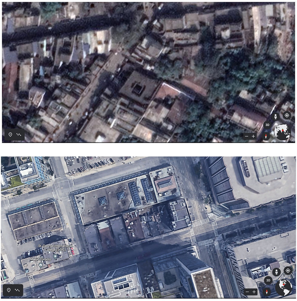
For Sen, Google Earth’s varying representations seem to imply that “some people’s homes are more important than others” (Sen 2017).
I agree. Think about the expression “put it on the map.” When someone says they want to be “on the map,” what they mean is that they want to be well-known. The unacknowledged assumption behind that metaphor is that in the literal sense, being on the map gives a place significance, legitimacy.
As Sen critically points out, it perpetuates “an essentialist white, Western perspective” that countries like India are “uncharted,” blank canvases, rather than the home of millions of people who are just as important as those living in Westernized countries.
And that’s not the only problem. The representation of India and surrounding countries on Google Earth reflects the divisions created by British authorities after the Partition of 1947. Villages are missing, images are hazy, and names are written that the people who live there don’t identify with. It’s clear that the data seen on Google Earth
perpetuates a violent colonial legacy still impacting those in India today.

As someone whose grandparents immigrated to Canada from India, Sen’s argument struck a chord. Generations upon generations of my ancestors who paved the way for me to be where I am today wouldn’t recognize the version of their home created by Google Earth that I accepted so quickly as a child playing around on a computer. The thought is unnerving, and also really sad.
Sen’s article inspired me, but also left me feeling like I wanted more. He doesn’t really provide any solutions to the problem he identifies. I started to realize, though, that Sen’s critique of the perception that Google Earth is “a color-blind technology” reminds me of something I read elsewhere.
In “Advancing Racial Literacy in Tech,” the authors identify that “the chief barrier to adopting a racial literacy approach is the belief that race doesn’t matter to technology” (6). What they’re getting at is that we can’t begin to combat the racial biases implicit in technologies until we admit that they exist.
That seems easy enough, but I do see how it could be difficult to even admit this is an issue. Online programs are made up of codes and mathematical equations – it might seem weird or even wrong to some to say that those things have the potential for bias when they seem so objectively-based. That’s certainly how I used to perceive Google Earth. But Sen’s article provided a nuanced analysis of the platform's biases that helped me work through that barrier.

So, though Sen’s article doesn’t directly propose a solution, its very existence enacts the first step of one. By reading more articles like his that interrogate biases in technologies, we can develop a greater understanding of how inequality is perpetuated by technology, overcoming our initial instinct to think of tech as colour-blind. It’s only when we work past that barrier that we can work towards racial literacy in technology and begin to search for solutions.


Comments